This feature is unavailable at the moment.
We apologize, but the feature you are trying to access is currently unavailable. We are aware of this issue and our team is working hard to resolve the matter.
Please check back in a few minutes. We apologize for the inconvenience.
- LoopNet Team
SH-20
Claremore, OK 74019
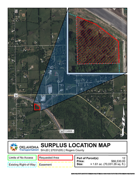
27031(05), Part of Parcel 12 · Land For Sale · 1.61 AC

Investment Highlights
- Clean Title
- Benefit the State of Oklahoma
- No Realtor / Commission Fees
PROPERTY FACTS
| Property Type | Land | Total Lot Size | 1.61 AC |
| Property Subtype | Residential | Cross Streets | S. Limestone Drive |
| Property Type | Land |
| Property Subtype | Residential |
| Total Lot Size | 1.61 AC |
| Cross Streets | S. Limestone Drive |
Description
A strip, piece, or parcel of land lying in part of the N/2 NE/4 SE/4 NW/4 NW/4 and that part of the SE/4 NE/4 NW/4 NW/4 of Section 8, T21N, R15E, in Rogers County, Oklahoma. Said parcel of land being described by metes and bounds as follows: BEGINNING at the SW corner of the N/2 NE/4 SE/4 NW/4 NW/4 of Section 8, T21N, R15E; thence N 01°11'26" W along the West line of said N/2 NE/4 SE/4 NW/4 NW/4 and said SE/4 NE/4 NW/4 NW/4 a distance of 322.26 feet to a point on the Permanent South Right-of-Way line of SH-20; thence S 68°33'47" E along the Permanent South Right-of-Way line of SH-20 a distance of 141.79 feet; thence S 52°49'58" E along the Permanent South Right-of-Way line of SH-20 a distance of 193.59 feet; thence S 01°15'23" E along the Permanent South Right-of-Way line of SH-20 a distance of 147.24 feet to a point on the South line of said N/2 NE/4 SE/4 NW/4 NW/4; thence S 88°44'29" W along the said South line a distance of 282.47 feet to said POINT OF BEGINNING. Containing 1.61 ac. (70,031.26 sq. ft.), more or less.
Links
Listing ID: 30019288
Date on Market: 09/11/2023
Last Updated:
Address: SH-20, Claremore, OK 74019
The Land Property at SH-20, Claremore, OK 74019 is no longer being advertised on LoopNet.co.uk. Contact the broker for information on availability.

